This is a somewhat longer walk of around 2 hours that takes you to the new wildlife interpretation centre created in the midst of Jersey’s ‘National Park’ in St Ouen’s Bay. As well as offering a place to view the wildlife on St Ouen’s Pond, it has dedicated touch screens that explain the flora and fauna of the bay.
This walk is wholly off-road, being mostly on St Ouen’s beach.
PLEASE BEWARE OF THE TIDES –
We are said to have the third-largest tides in the world, so please check a tide table before exploring the coastline!
Bus Route: 12 (to St Helier) or 22 (to St Helier) will take you back to the hotel.
Depending on the route that you take, you can expect a mixture of tarmac, cliff path and beach.
Walking Directions
Leave the hotel, and make your way to the main road, Le Mont de la Pulente. Cross over into Parcq de L’Oeilliere and turn right (the road has ‘No Entry’ marked on it). Follow the road through the estate and take the second right.
Walk on beyond the tarmac, soon we are on the headland that separates Petit Port from St Ouen’s Bay and a great panoramic view of the other islands can be seen to your right. Follow the track ahead, the Neolithic dolmen of La Sergenté can be found on the high ground over to the left.
La Sergenté Dolmen – The Beehive Hut
This is an early Neolithic passage grave that would have been built over 6,000 years ago; around 4,500 B C. It is thought that this was the first dolmen to be erected on the island. It is the sole example of this design in the Channel Islands, although similar dolmens are found in Normandy. In comparison with other passage graves, the ‘passage’ is particularly short and the circular shape is unusual. It has been constructed by a drystone-walling method, and it would have had a corbelled stone roof. The entire construction was then covered by a mound of earth.
The site was discovered in 1923, and excavations unearthed four undecorated, round-bottom pots. Again, these pots are unique to the islands and are of a style normally found in Western France.
Neolithic man lived in permanent settlements, where they raised animals and cultivated the land. The dolmen that we see around Jersey, are visible reminders of what they left behind; although it has to be said that there were many more dolmen built than are left today.
Walking Directions continued…
Return to the main track again and continue on towards the headland. Upon reaching a ‘crossroads’, with paths ahead and to each side, turn right and descend through a wooden barrier towards the broad sandy sweep of St Ouen’s Bay. Look out for a tree about three-quarters of the way down! When the steps reach a gravel path, cross over and follow a narrow path that runs below the road.
Some way along the path, go down the granite steps on the left. When these emerge onto tarmac, turn left and make your way towards the beach. Walk down the slipway onto the beach and turn right to walk towards the far end of the bay (we don’t actually go that far!). The most noticeable feature in the bay is the Jersey Round Tower.
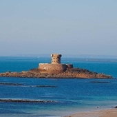
La Rocco Tower
This was the last of the 23 Jersey Round towers built. It followed Sir Seymour Conway’s original design, despite the English having adopted Martello towers sometime before. It was constructed between 1796-98.
Archirondel Tower which was built in 1794, served as the prototype for La Rocco. Like La Rocco, it had a parapet with a gun battery at its base. Archirondel could carry four 18 pounders, while La Rocco had five 32 pounders protecting it.
La Rocco Tower was named Gordon’s Tower by an Act of The States in May 1801, after Lt. General Andrew Gordon who was Lt. Governor between 1797 and 1806.
During the Second World War, the occupying forces allegedly used the tower as a target for artillery practice. It stood up to modern artillery well, but over time the wind and tide did further damage. In July 1968 an appeal was launched to raise funds to repair the tower; the sum raised would be matched by the Jersey Government. Within three months the target of £317,500 had been achieved.
Walking Directions continued…
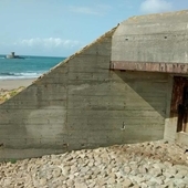
Walk on towards a granite outcrop ahead, with a Second World War bunker to the right of it. Most of the sea wall in St Ouen’s Bay was constructed as an anti-tank wall during the German Occupation of the islands. The flat sandy beach at St Ouen is ideal as a landing point for invading forces, hence the number of fortifications along its length. The Second World War bunker ahead of us is a good example of such a fortification.
La Carriere Coastal Casemate
In common with Jersey Round Towers, these fortifications are designed to slow down an invasion force rather than stop them landing at all. This can be endorsed by their line of fire which is along the beach, rather than out to sea.
Like all German fortifications built after 1941, these bunkers are of ‘fortress’ strength. That is to say, they have been built with walls and roofs of steel-reinforced concrete at least two metres thick. The complex here included two guns, a personnel shelter and a searchlight. It was equipped with a French-made 10.5cm K331(f) artillery piece, and a 4.7cm Pak K36 anti-tank gun, which was served by three NCOs and twelve other ranks.
There were as many as thirty-four of these K331(f) French guns in Jersey, they were captured in large numbers by the Germans as they advanced through France and many were taken from their gun carriages and used in coastal defences.
Due to this, many of our local coastal bunkers are of a unique design. They were designed by an Organisation Todt architect called Jager and consequently are called Jager casemates. This is a design peculiar to the Channel Islands although a few examples still exist in Denmark.
Walking Directions continued…
Continue along the beach for some distance, and aim for the steps at the end of the promenade on the right. The lookout tower of the RNLI lifeguards stands above it.
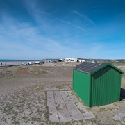
Climb the steps and walk on along the beachside promenade. After a short distance and before you reach the Watersplash Beach Bar and Diner, look to your right.
Europe’s oldest surf club
The innocuous little green hut is, in fact, the former HQ of Europe’s first ever surf club. Surfing became popular in Jersey in the 1920s when Major Nigel Oxenden returned to the island having learnt to surf on trips to South Africa and Hawaii. Initially, this was just in the form of belly-boarding on crude homemade boards but quickly developed with local Archie Maine said to be the first standup surfer in the late 20s.
Jersey has continued to be a surfing mecca ever since, hosting national and international tournaments throughout the 60s, 70s and 80s and surfing remains a very popular sport for locals and visitors alike. Today St Ouen’s Bay boasts five surf schools.
Walking Directions continued…
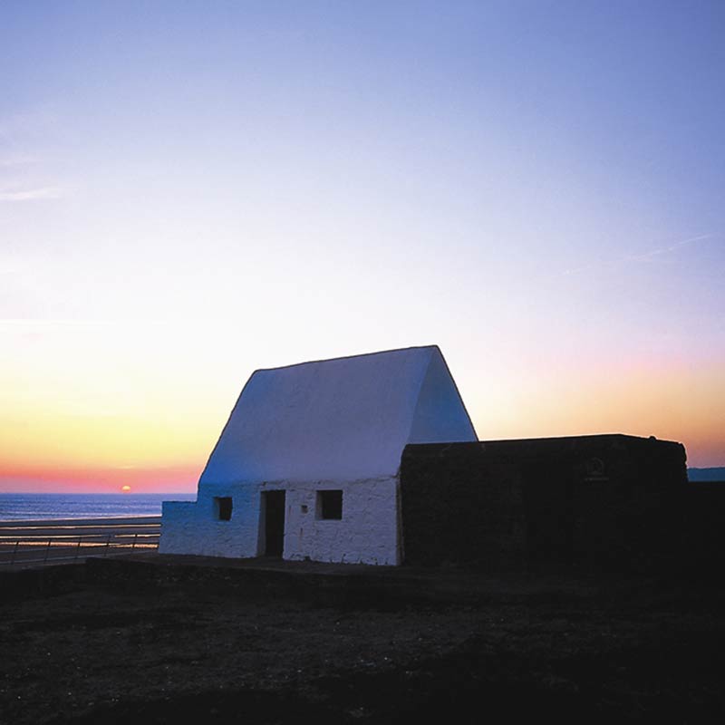
A short distance further, we can see a lone white building ahead. This was the site of the earliest defence ever built to safeguard the bay.
La Caumine a Marie Best
This was originally the St Peter’s Guardhouse, first recorded in 1665 when the defence of the bay was shared between the parishes of St Peter and St Ouen. This building was reconstructed in 1765 with a vaulted stone roof to serve as a powder magazine and guardhouse. Apparently, it replaced one that had earlier blown up!
On the 1817 Samuel John Neele map of St Ouen’s Bay, the site was called The Middle Battery. It was one of five batteries along the shore stretching from the Du Parcq Battery in the north to the Half Moon Battery in the south.
Mary Anne Best was the daughter of an English soldier and a local woman, Marguerite Carrel. She died in 1832 aged 41. It is believed that she moved her family here during a smallpox epidemic that was ravaging the island. When she died the building fell into disuse.
After the First World War, the bay became very popular as a weekend retreat.
Lieutenant Colonel J A Hilton acquired the guardhouse and the northern part of the site in 1932. In 1975 his widow, Mrs Marie Hilton gave it to the National Trust for Jersey. Painted white to act as a navigation aid, the little house gets its name from the lady who lived there after it had fulfilled its military purpose.
Among the plants that grow here are Common Thrift, Jersey Thrift and Alderney Sea-Lavender.
Walking Directions continued…
At the end of the concrete promenade, bear right to make your way around another German defence and almost immediately turn right towards the road. At the roadside, turn left and walk along the narrow gravel path for a few yards; the Wetland Centre is just across the road. The Centre is an exceptionally good interpretation facility for the numerous and varied wildlife species in the bay.
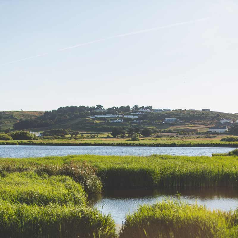
St Ouen’s Pond – La Mare au Seigneur
This is the largest area of natural freshwater to be found in the Channel Islands. Once belonging to the Seigneur of St Ouen’s Manor, it is also known as La Mare au Seigneur. It provided a stock of fish for the manor and a place to hunt. Today the pond is looked after by The National Trust for Jersey. It is an extremely important site for wildlife, especially birds. It is a permanent home to Mallards, Moorhens, Cetti’s Warblers and Reed Buntings and a winter home to Grey Heron, dark-bellied Brent Geese, Great Bittern and Shovellers amongst others.
To return to the hotel, you can either retrace your walking route or use one of the following:
Bus Route: 22 (to St Helier) There is a stop on the same side of the road as the Wetlands Centre to the left of the entrance, ask for The Atlantic Hotel. See times for the buses under Jersey Pearl. Click here for the full timetable.
Taxi: Domino Cabs are based in St Brelade – Telephone: +44 (0) 1534 747047