A bracing walk to Corbiere Lighthouse

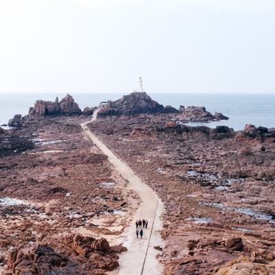
The Corbiere Lighthouse walk is approximately 45 minutes and will take you to Corbiere Lighthouse, one of the island’s most iconic, and indeed most photographed, landmarks. Apart from its glorious setting, it also has the distinction of being the first concrete lighthouse to be built in the British Isles.

This walk is nearly all off road, apart from a short stretch of roadside walking in the middle of the route.

PLEASE BEWARE OF THE TIDES –

We are said to have the third largest tides in the world, so please check a tide table before exploring the coastline!

Click here to check the latest Jersey tide times

Mileage:  1.6 miles / 2.5 kilometres to get there

Time: 45 Minutes

Elevation range:  150 feet / 45 metres

Bus Route:  12 (to Greve de Lecq) and 22 (to L’Etacq) will take you back to the hotel

Expect a mixture of tarmac, cliff path, gravel railway path and concrete.

Walking Directions

Leave the hotel, and make your way to the main road, Le Mont de la Pulente. Cross over into Parcq de L’Oeilliere and turn right (the road has ‘No Entry’ marked on it). Follow the road through the estate and take the second right.

Walk on beyond the tarmac; soon we are on the headland that separates Petit Port from St Ouen’s Bay and a great panoramic view of the other islands can be seen to your right. Follow the track ahead, the Neolithic dolmen of La Sergenté can be found on the high ground over to the left.

railway walk jersey

La Sergenté Dolmen – The Beehive Hut

This is an early Neolithic passage grave that would have been built over 6,000 years ago; around 4,500 BC. It is thought that this was the first dolmen to be erected on the island. It is the sole example of this design in the Channel Islands, although similar dolmens are found in Normandy. In comparison with other passage graves, the ‘passage’ is particularly short and the circular shape is unusual. It has been constructed by a drystone-walling method, and it would have had a corbelled stone roof. The entire construction was then covered by a mound of earth.

The site was discovered in 1923, and excavations unearthed four undecorated, round-bottom pots. Again, these pots are unique to the islands and are of a style normally found in Western France.

Neolithic man lived in permanent settlements, where they raised animals and cultivated the land. The dolmens that we see around Jersey, are visible reminders of what they left behind; although it has to be said that there were many more dolmens built than are left today.


Walking Directions continued…

Return to the main track, and walk on. Near a drain cover, where we have a choice of routes, turn left to descend through a wooden barrier. Follow this sandy path as it makes its way downhill. When it meets another sandy path at right angles, turn left. Continue along the path. On reaching tarmac again, turn left and climb a slight hill (Le Chemin de Petit Port) to the road.

At the yellow line turn right, and walk along the road. The rocky foreshore below is home to a number of Little Egrets. Just after a rocky outcrop, a foot path sign appears on the left-hand side of the road, follow the sign up several wooden steps.

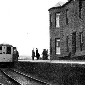
When the path emerges onto a wider gravel track, turn right. This is the old route of the Jersey Rail and Tram Company.

corbiere lighthouse walk

Jersey Railway and Tram Company

The railway opened to the public on 25th October 1870 with a line out to St Aubin. There were stations at First Tower, Millbrook and Beaumont. In May the following year, the company opened a hotel at St Aubin just behind the station. This was known as The Terminus Hotel.

Initially, it was well patronised; there was a bar directly accessible from the platform and a coffee shop above. No less than 9,000 passengers used the line on the second Saturday after the hotel opened. Unfortunately, this popularity was hard to maintain; the company changed hands regularly during the time the line ran from St Helier to St Aubin, and later to La Corbiere.

The idea to construct a line to service La Moye Quarries, near La Corbiere, was mooted as early as 1871. This finally came to fruition in August 1884, when the line from St Aubin’s Hospital ran out to the quarry. The track was extended to La Corbiere and opened to the public in July 1899.

Due to a decline in revenue in later years, and in an effort to defray running costs, the line was only used during the summer.

The final blow was struck in the early hours of Sunday October 18th, 1936 when a disastrous fire took hold in a butcher’s shop bordering the station. Within a very short time, the fire had spread and threatened to engulf the Terminus Hotel. At the final reckoning, five shops were destroyed, 16 of the company’s newest carriages had been reduced to ashes and so had the station roof.


Walking Directions continued…

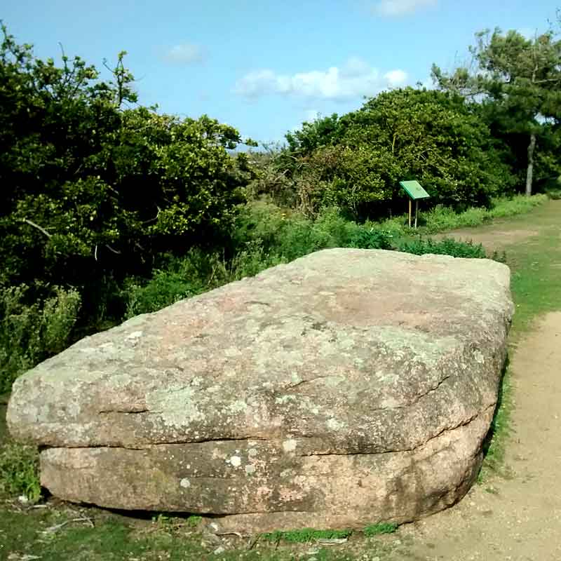
As we approach the granite railway terminus, we pass a large granite capstone on our right. This is called La Table des Marthes.

railway walk jersey

La Table des Marthes

This enormous stone is thought to be the capstone of a dolmen. The site was examined in 1850, and it was found that the stone was supported by stone pillars underneath it.

There are several uses for this flat stone: it was once used for signing contracts, and in fact, contracts signed in this way were considered to be especially binding. On a lighter note, it was often used by schoolboys for playing marbles.


Walking Directions continued…

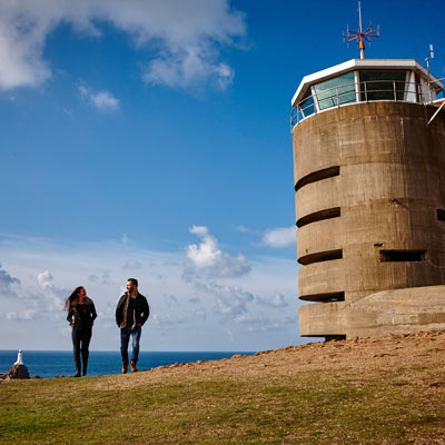
The structure on our left was once the railway platform. Immediately before the terminus building is a short flight of steps, walk up these and cross the car park to the road. Taking care; cross the road and bear left towards the concrete tower ahead. This was a range-finding tower built by the Germans during the Second World War.

railway walk jersey

MP 2 La Corbiere Range-finding Tower

Today, three of these robust towers can be found in Jersey; at Noirmont, Les Landes and here at La Corbiere. The original plan was to build a total of nine towers around the coast of the island but the war ended before this was achieved.

Their purpose was to gauge the range of targets out at sea. This one, at La Corbiere, was built to direct the fire of a battery of four 22cm K532(f) guns that was situated roughly where Le Mont es Croix housing estate and HM prison La Moye stand today, about a mile to the east of the tower.

Known as Batterie Roon, this battery of guns had a compliment of 144 troops. In addition to the artillery pieces, it also had six 8.8cm Flak 37 and two 2cm Flak 38 anti-aircraft guns. In German, acht is the word for eight, which is why anti-aircraft guns are often called ack-ack guns.

The glass observation area at the top of the tower was once home to Jersey Radio, a service that monitored marine movements in the English Channel. This has now been moved to St Helier Harbour, and the building has been repurposed as a Heritage Let, offering self-catering accommodation for up to six people.


Walking Directions continued…

Leave the tower, and cross the scrubland towards the rocky outcrop beside the road. On reaching the road turn left and descend to the car park. A magnificent view of the lighthouse can be seen from this vantage point.

corbiere lighthouse walk

La Corbiere Lighthouse

This lighthouse, which stands at Jersey’s most south westerly point, has the distinction of being the first concrete lighthouse built in the British Isles. The light came into service in 1874. It was designed by the marine architect Sir John Coode and built by engineer Imrie Bell.

Originally powered by paraffin, it switched to electricity in 1965. The current strength of the beam is 1000 watts, visible for 18 miles in good conditions from the 62’ tall lighthouse. In foggy conditions, a bell was rung but this was replaced in 1933 by a fog horn operated by compressed air.

Since 1976, there has been no lighthouse keeper, as the light now runs automatically. Previously a team of four lighthouse keepers, working in pairs, manned the site. Each pair would spend 48 hours in the lighthouse with each man doing a six-hour shift. If conditions were extremely bad both would be on duty.

The Clasped Hands memorial that stands beside the road to the lighthouse proves that seafaring incidents are not always a thing of the past. The sculpture was created by Derek Tristram from a perfect piece of granite that had previously been in the harbour wall in St. Helier and was unveiled on April 17, 1997, by former local politician Senator Tony Chinn. It records an incident in April 1995, when a Channiland catamaran struck La Frouquie rock, 900 metres north of La Corbiere. Due to the ship’s position, and the fact that it was an Easter Bank Holiday, the rescue services arrived very quickly and all 307 passengers and crew were rescued safely.


To return to the hotel, you can either retrace your walking route or use one of the following:

Bus Route:
22 (to L’Etacq)
Get on at the bus stop alongside the old railway station and ask for The Atlantic Hotel. Click here for the full timetable.

Taxi:
Domino Cabs are based in St Brelade – Telephone: +44 (0) 1534 747047

Download the Corbiere Lighthouse Walk PDF